Did BP Accidentally Tap Into the Rigel Gas Field?
Politics / Environmental Issues Jul 29, 2010 - 05:18 AM GMTBy: Washingtons_Blog
 On July 23rd, Admiral Thad Allen said that the seep 3 kilometers from the leaking BP well was from the Rigel gas field: David Dishneau: Admiral, this is David Dishneau from The Associated Press. I have a question regarding that seep that we’ve been trying to, that was identified within three kilometers… And I know that the Interior Department now is trying to assist with identifying that but the AP has developed a map that shows the two old wells within the radius that you described. And I wondered if I could show you this map and you could point out which of those you believe.
Admiral Allen: You caught me without my glasses. I think I can answer your question. I think we believe it might be attributed to what’s called the Rigel well, r-i-g-e-l
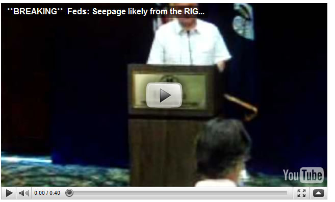
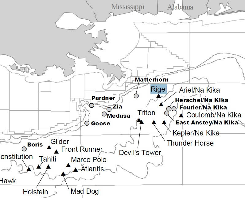
Rigel is a huge deepwater gas field.
Portions of the gas field are directly south of the blownout BP well in Mississippi Canyon Block 296 (MC296), as well as in Mississippi Canyon Block 252 (MC252), where BP's blownout oil well is located:
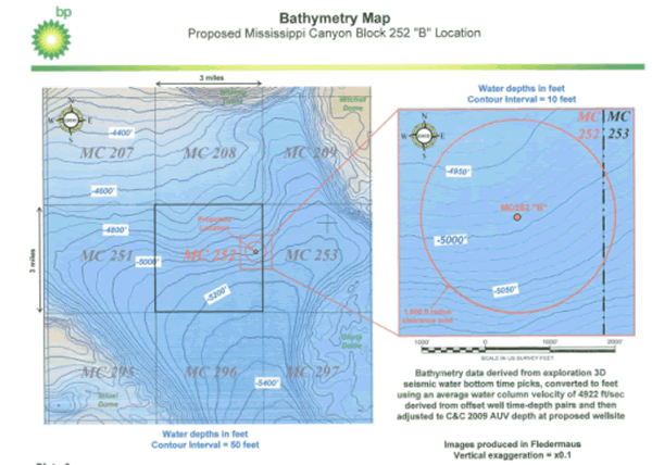
In a series of 3 articles, Florida Oil Spill Law (FOSL) rounds up information on the Rigel gas field, and its potential interaction with BP's oil well.
Initially, FOSL provides general background on the Rigel field:
Federal officials visit oil spill area, talk with BP, Oil & Gas Journal, April 30, 2010:
Transocean Ltd.’s Deepwater Horizon semisubmersible was on contract to BP to drill the Macondo well on Mississippi Canyon Block 252 in 4,992 ft of water near Rigel gas field. An Apr. 20 explosion and fire rocked the semi, leaving 11 crew members missing and presumed dead and injuring 17.
Westside – Rigel Deepwater Field Appraisal and Development, Westside Study Group, November 16, 2005
The Rigel exploration well, the Texaco OCS-G-18207 #1, was drilled in 1999 in Gulf of Mexico block MC 252 in 5200’ water depth. The well targeted a Miocene age, low-relief downthrown closure/stratigraphic trap that was supported by a strong amplitude response on the 3D seismic data. … The well encountered what was interpreted to be a 176’ thick gas-charged, low-permeability siltstone in the Rob E-age target. …
The appraisal drilling by Dominion, the operator, with its partners, Mariner and Newfield, was highly successful. As a result, the Rigel field is currently being developed as a one-well subsea tieback, as part of a larger subsea system. The project is nearly complete.
MTS Houston presentation May 25 to feature Dominion’s Rigel/17 Hands Subsea Development in the GOM, Oil Online, April 6, 2006:
Rigel/17 Hands is a two-well, subsea, dry gas development in the Mississippi Canyon 252 area of the Gulf of Mexico, in water depths ranging from 3400 feet to 5800 feet. The two wells are tied back to the Chevron VK 900 host facility via the alrea flowline. All the equipment and controls were designed to be compatible with the existing Chevron system.
The distance from the host facility to the Rigel and 17 Hands wells is approximately 40 and 50 miles, respectively. Combined flow rates from the two dry gas wells is around 150 MMCFPD.
Dominion Makes Deepwater Discovery at Rigel Prospect, Rig Zone, November 05, 2003:
Dominion Exploration and Production has made a deepwater discovery at its Rigel prospect, located at Mississippi Canyon Block 296 in the Gulf of Mexico. The discovery is located in about 5,200′ of water… drilled to a total depth of about 16,200′ and encountered 140′ of gross gas pay in the main Rob E objective. Additional pay was found in a shallow objective that may allow for a future recompletion. The well has been temporarily abandoned for future use as a subsea completion.
Cal Dive Installs 17 Hands and Rigel Flowline System, Rig Zone, June 06, 2005:
Cal Dive International recently completed the installation of Dominion Exploration & Production’s 17 Hands and Rigel flow line system. The project included the installation subsea to subsea of 121,072 feet of 8 inch diameter pipe in water depths ranging from 3,500 to 5,883 feet from CDI’s reel lay vessel Intrepid. The pipe lay operation was initiated at the 17 Hands well location in MC 299 utilizing Cal Dive’s hinge over Pipeline End Termination (“PLET”) system, an in-line PLET was installed at the Rigel well in MC 252 then the flowline system was terminated with a standard second end PLET at the Gemini manifold location in MC 292.
Speculation about a possible impact on the Rigel well did occur at the Oil Drum. Once. About a month ago.
BP’s Deepwater Oil Spill – The Admiral on Casing and Connections, Oil Drum, June 21, 2010:
[Comment by Lurking]
Anybody happen to know if the Rigel or 17 Hands gas fields are in danger of being affected by fluids from the BP stovepipe?…
The reason I ask is that over the last few days, I’ve seen what appear to be more gas in the plume… as if I can tell what it is when I see it. I’m referring to the globs of bluish white that you see in the plume.. not the milky dispersant from the nozzles. I have no idea what the pay depth for those two fields are, but if they are contributing to the flow… that would be bad.
[Response by Bignerd]
Funny, I was looking at that the other day.
I’ve got a map which shows what I think is the Macondo well over to the east side of the 252 block, whereas the Rigel field straddles the southern boundary.
The Seventeen Hands gas line and an oil export line from Na Kika both cross the block in the south and west.
So all other on block infrastructure looks to be about 3 km to the south and west of the Macondo well.
[Response by Lurking]
The Rigel prospect has a measured depth of 16,200 feet. Macondo was drilled to 18,000 feet (and change). … [My comment: there is "weakness" in the blown out Macondo well at 9,000 and 17,000 feet]
[I]t seems to me that 3 to 7 miles is not that far in strata that is as close as 340 vertical feet apart and that varies from impermeable to highly porous.
[The Macondo well] had to drill past (through?) that level [of the Rigel well] with what is now a casing of dubious integrity.
Next, FOSL asks whether it is possible that gas from the Rigel field is flowing in to BP's blown out oil well:
Is the Rigel gas field why Congressman Markey’s wrote the mysterious June 23 letter about oil flowing into the well?
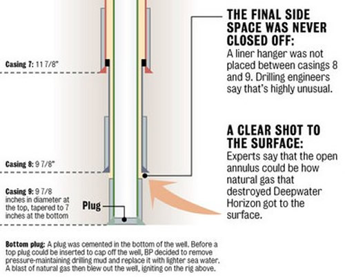
See 'Clear Shot to the Surface' (Times-Picayune)
“Experts say that the open annulus could be how [a methane bubble] that destroyed the Deepwater Horizon got to the surface.” - Times Picayune
The nearby Rigel gas deposits are at a similar depth to the compromised section of BP's Macondo well.
***
Congressman Markey’s June 23 letter to BP question[ed] if hydrocarbons may also be rushing IN to the damaged casing, instead of pouring out. His questions were revealing, and now more relevant than ever:
Are there significant deposits of oil and gas in formations above the target reservoir?
Please provide an estimate of the total amount of oil and gas that is contained in i) the Macondo well target formation and ii) each formation above the target formation that could leak hydrocarbons into the annulus…
Please provide documents related to the possibility that the initial drilling encountered leakage from other formations above the target reservoir…
A May 23, 2010 article… in the Orlando Sentinel stated that well records indicate that in late February, there was a loss in drilling mud pressure. According to the article, this could mean that the mud fractured layers of sand or shale in the formation and vanished. The article goes on to state that in early March, the pressure of the oil and gas encountered overwhelmed the pressure of the drilling mud. In mid-April, a loss of drilling mud was reportedly again experienced. Do any or all of these events indicate that oil and gas could be flowing from somewhere other than the target reservoir? If so, please explain fully, and if not, why not?
How does Conressman Markey know to pursue such unique and specific questions about the well integrity? Previous to this letter, no mention had been made of leakage INTO BP’s well, the possibility of oil or gas escaping out.
Markey likely already knows the answers to these questions, but is unable to reveal this information because it is under some level of classification.
He recently made a statement to this effect on CNN: Rep. Markey says Congress unable to “PUBLICLY disclose” integrity of wellbore — More (VIDEO)
MARKEY: They have not responded. And, again, I wrote back there on June 23, so that we could publicly disclose what the integrity of the wellbore is, we could publicly disclose what the integrity of the geology around the wellbore, so that we could better understand. …
Given the heated debates as to whether or not BP's oil reservoir is becoming depleted, what the pressure readings from the BP well mean, and whether a "static kill" (top kill version 2.0) attempt is safe, it is crucial that we get to the bottom of this one way or the other.
Finally, FOSL points out that - instead of Rigel gas leaking into the BP well - the BP oil spill could have leaked out through the area of the Rigel gas field:
The seeps were identified by the Joint Analysis Group and research vessel Thomas Jefferson.
The Joint Analysis Group is comprised of the National Oceanic and Atmospheric Administration (NOAA), the U.S. Environmental Protection Agency (EPA) and the White House Office of Science and Technology Policy (OSTP).
Several seeps southwest of the BP blow-out were first reported on June 21, 2010 by scientists aboard the R/V Thomas Jefferson. The seepage “appears to be natural gas” (methane) according to the NOAA report.
Did these seeps exist before BP began exploration of the doomed Macondo prospect?
Former Shell Oil executive and current Berkeley engineering professor Robert Bea is “troubled that we’re just now hearing about seeps three kilometers away, because a survey of the seabed conducted before BP drilled its well didn’t indicate anything like that,” according to the Times-Picayune.
He said, “There was nothing that indicated the presence of such a seep… I wonder why we’re just now finding that out?”
Bea has “very little confidence in what’s been said publicly about the seeps.”
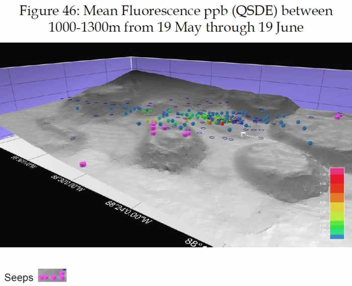
This July 23 JAG report image shows areas of seepage near the BP blow-out, with the majority appearing near the Rigel gas field. Seeps are identified by purple cylinders:
BP blow-out = white cylinder (NOAA)
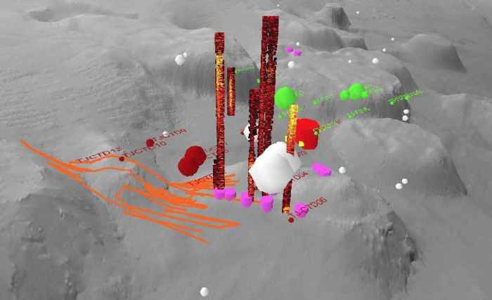
Seeps shown as ‘red and yellow columns’ & ‘purple cylinders’ in the June 21 report by the R/V Thomas Jefferson:
BP blow-out = solid bright red cylinder
I have no idea whether or not FOSL is correct that a substantial interaction between the blownout BP well and the Rigel gas field has occurred. I have repeatedly noted that the oil gusher could make nearby natural seeps larger. And the crude from BP's well is 40% methane, while crude oil usually contains only 5% methane. Is this because of a naturally high methane content in the oil reservoir, or because BP accidentally tapped into the Rigel field while it was drilling?
It is better to raise the hypothesis that the BP oil well is interacting with the Rigel field and have it debunked - or confirmed - than not to discuss it at all ... especially since Thad Allen has raised the issue himself.
Better yet, BP should be forced to answer Congressman Markey's questions, so that we don't have to speculate.
Numerous people have also sent me the link to Alexander Higgins' post claiming that the large methane seep in the area of the Rigel field was
Global Research Articles by Washington's Blog
© Copyright Washingtons Blog, Global Research, 2010
Disclaimer: The views expressed in this article are the sole responsibility of the author and do not necessarily reflect those of the Centre for Research on Globalization. The contents of this article are of sole responsibility of the author(s). The Centre for Research on Globalization will not be responsible or liable for any inaccurate or incorrect statements contained in this article.
© 2005-2022 http://www.MarketOracle.co.uk - The Market Oracle is a FREE Daily Financial Markets Analysis & Forecasting online publication.


